The walk is covered on the following maps:
- OS Landranger Map No 102 – 1:50,000 scale
- OS Explorer Map No 286 – 1:25,000 scale – preferable for walking
The route and photos are available in a printable pdf - download here.
The route is described from the skew bridge.
Dogs - please note - there are restrictions on dogs within the Brockholes Nature Reserve - they are only allowed on the Public Right of Way, and on leads.
|
Walk towards Preston until you come to the very last house in Grimsargh on the left-hand side of the road. You will see (look carefully!) a footpath sign and a gap in the fence. Go through and follow the path all along the edge of the industrial estate. |
 |
|
|
You will come to a stile – cross over. You will then see another stile immediately on the left. Don’t cross this one – continue along the path that runs to the right hand side of the fence. There can be nettles along this path, so good leg protection is recommended. |
 |
|
|
At the end of the path you will come to another stile. Cross over onto the track – which can be very muddy! Continue following this track. It will go through a sharp right hand bend – keep going until the track comes to an effective end. |
 |
|
|
At this point turn sharp left through 90°. Head directly across the field – there is a crooked tree in the distance standing some way forward of the main woods – head towards it. Like many fields in this area, being clay soil it can be very wet! |
 |
|
|
As you get closer to the tree you will see there is a stile beyond it – cross over into the woodland. You are now on the Ribble Way. Turn right and follow this path. |
 |
|
|
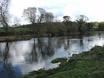
It is a fairly well maintained path and easy to follow. You are walking along the top edge of the Ribble Valley, through Boilton Wood, with the river down to your left. At times it can be glimpsed through the trees of this ancient, unspoiled woodland. |
 |
|
|
After the path turns a little left and is travelling south, you will be aware of routes through to the right which lead to a gravel track which runs in parallel with the Ribble Way at this point, and will form part of the Guild Wheel, once complete. You can either walk along the track, or stick to the woodland path. |
 |
|
|
The track will lead more directly to the newly constructed path which leads down to the Brockholes Nature Reserve. The Guild Wheel is, generally, intended to be suitable for cycling. For this section, cyclists are going to be requested to dismount. It is a very pleasant, though quite steep path. |
 |
|
|
There are barriers placed across the path to ensure that cyclists don’t hurtle, unchecked, down the hill! This photo is taken looking back up the hill.
|
 |
|
|
There are a couple of choices of route into the nature reserve, marked by these “motorbike prevention” gateways. |
 |
|
|
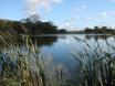
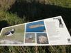
You will be entering the reserve from the north Boilton Wood There is lots of information on the Nature Reserve on the Brockholes website. Their welcome leaflet can be downloaded here. There is a series of walks that you can do around the reserve. |
 |
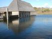
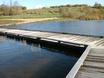
The reserve is very well laid out and the staff at the visitor centre are extremely friendly and helpful – and it’s all free – if you walk! For more information, see the website: www.brockholes.org.
The return journey is the reverse of the route to get there.
Sometime during early 2012, the Guild Wheel was completed, giving a gravel or tarmac pathway from Longridge Road – around about the entrance to the Crematorium, alongside Pope Lane recreation ground and joining the route at Boilton Wood. This should be a more “friendly” route for those without good water/mud proof boots!